We have compiled a list of manufacturers, distributors, product information, reference prices, and rankings for GNSS receiver.
ipros is IPROS GMS IPROS One of the largest technical database sites in Japan that collects information on.

GNSS receiver(co) - List of Manufacturers, Suppliers, Companies and Products | IPROS GMS

Last Updated: Aggregation Period:Jul 15, 2026~Aug 11, 2026
This ranking is based on the number of page views on our site.

GNSS receiver Product List

1~10 item / All 10 items

Displayed results

Cohac∞ Series

Michibiki-compatible high-precision positioning solution Cohac∞ series

The "Chronosphere-L6" receiver is compatible with the centimeter-level positioning augmentation service (CLAS/MADOCA) of the Quasi-Zenith Satellite System "Michibiki." It achieves centimeter-level positioning across the entire Michibiki area (including Japan and the Asia-Oceania region) without the need for communication costs (no ground communication required). Additionally, it ensures accuracy and stability by supporting signals not only from "Michibiki" but also from GNSS systems worldwide.

  • others
  • GNSS receiver

Added to bookmarks

Bookmarks list

Bookmark has been removed

Bookmarks list

You can't add any more bookmarks

By registering as a member, you can increase the number of bookmarks you can save and organize them with labels.

Free membership registration

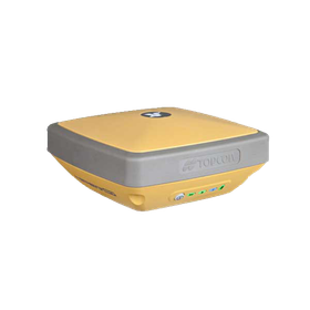
TOPCON:GNSS『HiPer SR』

Compact and lightweight all-in-one receiver suitable for both surveying and civil engineering.

【Features】 ■Easy and simple measurement by one person ■Robust body strong enough for harsh environments ■LongLink data communication ■Excellent environmental performance IP67 ■Achieves over 15 hours of continuous use ■Compatible with the Quasi-Zenith Satellite System *For more details, please refer to the PDF document or feel free to contact us.

  • others
  • GNSS receiver

Added to bookmarks

Bookmarks list

Bookmark has been removed

Bookmarks list

You can't add any more bookmarks

By registering as a member, you can increase the number of bookmarks you can save and organize them with labels.

Free membership registration

[Latest Information] TOPCON: GNSS 'HiPer CR'

High positioning performance and a simple interface will change surveying work!

【Features】 ■ Compatible with all satellites ■ Ultra-compact and robust body ■ Easy and simple interface ■ Compatible with hybrid survey systems ■ LongLink data communication ■ Built-in battery with 10 hours of operation *For more details, please refer to the PDF document or feel free to contact us.

  • others
  • GNSS receiver

Added to bookmarks

Bookmarks list

Bookmark has been removed

Bookmarks list

You can't add any more bookmarks

By registering as a member, you can increase the number of bookmarks you can save and organize them with labels.

Free membership registration

GNSS receiver "OEM board"

Sales of OEM boards compatible with GNSS have been realized! Products from Javad GNSS incorporating next-generation signals.

We would like to introduce our "OEM Board." This product is a simple unit that integrates everything, including a receiver, antenna, battery, transceiver system, MENS, multiple antenna terminals for attitude control systems, and Bluetooth functionality for wireless communication with PDAs. The 219-channel LSI engine is fully compatible with additional functionalities such as Europe's Galileo, Japan's QZSS, and China's Compass. 【Features】 ■ A simple unit that integrates everything ■ High-precision surveying analysis software and advanced GIS software will also be released simultaneously ■ The 219-channel LSI engine is fully compatible with additional functionalities such as Europe's Galileo, Japan's QZSS, and China's Compass *For more details, please refer to the PDF materials or feel free to contact us.

  • Other measurement, recording and measuring instruments
  • GNSS receiver

Added to bookmarks

Bookmarks list

Bookmark has been removed

Bookmarks list

You can't add any more bookmarks

By registering as a member, you can increase the number of bookmarks you can save and organize them with labels.

Free membership registration

Measurement and Survey

We have introduced numerous specialized technicians and surveying equipment that pursue "measurement"! We provide services that are "trustworthy and satisfying."

We would like to introduce our "Surveying and Research" services. Geospatial information has become an important infrastructure as the foundational information for national land and corporate management. Our company is constantly pursuing "measuring technology." We have introduced numerous specialized technicians who focus on "measuring" and new surveying equipment, promoting advancements and cost reductions to provide our customers with services that are "trustworthy and satisfactory." 【Service Details (Excerpt)】 <Main Services> ■ Control Point Surveying ■ Digital Terrain Surveying ■ Applied Surveying ■ Various Investigations ■ Land Registry Surveying *For more details, please refer to the PDF document or feel free to contact us.

  • Other contract services
  • GNSS receiver

Added to bookmarks

Bookmarks list

Bookmark has been removed

Bookmarks list

You can't add any more bookmarks

By registering as a member, you can increase the number of bookmarks you can save and organize them with labels.

Free membership registration

K8 board equipped GNSS receiver 'T300Plus'

Equipped with an IMU, it can correct tilts of up to 60°!

Equipped with the latest cutting-edge K8 board! 【Application】GNSS Surveying 【Features】 ■ Multi-GNSS compatible: Equipped with BeiDou satellite reception ■ Satellite tracking channels: 965 channels ■ IMU included → Calibration completed in under 10 seconds → Capable of correcting tilt up to 60° *For more details, please refer to the PDF document or feel free to contact us.

  • Other embedded systems (software and hardware)
  • GNSS receiver

Added to bookmarks

Bookmarks list

Bookmark has been removed

Bookmarks list

You can't add any more bookmarks

By registering as a member, you can increase the number of bookmarks you can save and organize them with labels.

Free membership registration

[Discontinued] GNSS Handheld [Trimble TDC150]

GNSS observations can be made in the mountains and forests! From survey-level to GIS applications, a full GNSS receiver integrated high-precision and high-functionality handheld device.

A GNSS-integrated handheld device that can be used easily and with high precision even in concealed environments. It is an ideal receiver for infrastructure management in forests and urban areas. The rugged casing equipped with Android OS is suitable for use in harsh environments. With four types of device configurations that offer precision from 1 cm to meters, you can choose the grade according to the required accuracy. Upgrading the accuracy temporarily or permanently is also possible with options. It supports satellite signals from GPS, Galileo, BeiDou, GLONASS, and QZSS, as well as various corrections such as SBAS, VRS, and RTK. It comes standard with a built-in camera and electronic bubble level, allowing for comprehensive operations with a single device. The battery, which can be charged via USB, lasts for 8 hours and is replaceable. 【Features】 - Capable of obtaining coordinates with an accuracy of 1 to 100 cm (diameter) even in forests, residential areas, and quarries. - Equipped with front and rear cameras, allowing for photography of measurement locations. - Ideal for infrastructure location information (manholes, gas pipes, water pipes, utility poles, steel poles, etc.). - On-site inspections of solar panels and wind power generation. - High-level GNSS reception performance in harsh environments like forests, maximizing positioning quality even under canopies. - The Dm compliant with water service providers has a vertical accuracy of 2 cm.

Added to bookmarks

Bookmarks list

Bookmark has been removed

Bookmarks list

You can't add any more bookmarks

By registering as a member, you can increase the number of bookmarks you can save and organize them with labels.

Free membership registration

Integrated antenna GNSS receiver 【Trimble R580】

Proven and reliable positioning. Multi-GNSS compatible, mid-range surveying GNSS receiver.

The Trimble R580 GNSS receiver is an antenna-integrated GNSS receiver that supports multi-satellite and multi-frequency. It is equipped with high-performance features advantageous for observations, such as the surveying engine "ProPoint" and multipath removal technology "EVEREST Plus." Weighing only 1.08 kg, it is lightweight and easy to handle, minimizing the pull of weight when mounted on a pole, which reduces fatigue during long observation sessions. Additionally, the controller used to check observation results connects to the receiver via Bluetooth, allowing for cable-free and agile operation. It can be connected to the SKY Controller, LANDRiV PRO Controller, and Trimble Access for various surveying tasks.

Added to bookmarks

Bookmarks list

Bookmark has been removed

Bookmarks list

You can't add any more bookmarks

By registering as a member, you can increase the number of bookmarks you can save and organize them with labels.

Free membership registration